Itinerary “Le Borgate” (The Districts)
Duration: ca. 4 h • Altitude difference:
250 m
Difficulty: a walk suited for everyone
Recommended period: All year round.
In winter
with snow shoes, except for the slope
towards Champanho due to avalanche risk.
Itinerary “Le Mèire” (Alpine stone houses)
Duration: ca. 3 h • Altitude difference:
300 m
Difficulty: a walk suited for everyone
Recommended period: All year round.
In winter with snow shoes.
Itinerary “I Pascoli” (The Pastures)
Duration: ca. 6 h • Altitude difference:
740 m
Difficulty: trekking
Recommended period: All year round.
In winter with
compacted snow and equipment for back-country skiing
or snow shoes (avalanche risk in the
sections Rouquét-‘Slaço and Pèiro Groso-Rocho dë l’Àio)
----------------------------------------------------------------------
Itinerario “Le Borgate”
la Villo (Villa), Champanho (Ciampagna), lou Sère (Serre) la Ruà (Bernardi),
San Bërnart (San Bernardo), la Villo (Villa)
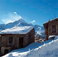 Pleasant and interesting walk, on a route not very strenuous but rich in varied landscapes that allows the exploration of a vast area of the Oustano territory. In some parts the organized network of trails winds through dense wooded areas that usually thin out around the districts and the main settlements. This circular route gives the hiking tourist the opportunity to gradually discover the local architecture and construction types. Observing the habitations (predominantly those that were not restored recently), the ovens, the fountains and washing troughs, the chapels and wayside shrines, traces that hint to old and highly demanding crafts can be detected.
Duration: ca. 4 h • Altitude difference:
250 m
Difficulty: a walk suited for everyone
Recommended period: All year round.
In winter
with snow shoes, except for the slope
towards Champanho due to avalanche risk.
Itinerary “Le Mèire” (Alpine stone houses)
Miribrart (Sant’Antonio), lou Sère (Serre Inf.re – Sup.re), i Durandin,
le Mèire da Crouç, Sarlichart, la Ruà (Bernardi), Sërét, Strada Comunale dei Bernardi, Miribrart (Sant’Antonio)
Starting in the district Miribrart one follows the spring relocation that once upon a time was undertaken by the families who lived all year round with their livestock in the municipality of Ostana. When at the end of May the practise of sharing communal pasture, which had been interrupted in autumn, was taken up again, the people settled down in their summer habitations, commonly called mèire. Hiking the typical Vio dal Sère and ascending to the point where one meets the trail la Draio dë Chazarlonc, which was usually trodden by the herds, one passes the settlements Durandin and Mèire da Crouç. On the way one crosses the trails of numerous bialìëre (canals), a testimony to the ingenious water canalization works. A stop at the plateau Samicoulàou is recommended, where the chapel of the same name, which is considered the oldest parish of Ostana, can be admired.
Duration: ca. 3 h • Altitude difference:
300 m
Difficulty: a walk suited for everyone
Recommended period: All year round.
In winter with snow shoes.
Itinerary “I Pascoli” (The Pastures)
Pion da Charm (1,635 m), Coumbo Frino, l’Arp, la ‘Slaço (Punta Selassa – 2,036 m),
Col Bërnart (Colle Bernardo – 2,245 m), la Pounto dal Razil (2,370 m),
Punta Ostanetta (2,375 m), lou Col dal Valoun (Colle del Vallone – 2,247 m),
Pion des Fountane, Rocho dë l’Àio, Draio des Case, Draio dë Pèiro Groso, Pèiro Groso, la Gravëllo, Pion da Charm
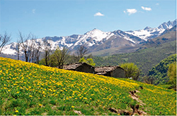 This itinerary leads across the rich pastures to the peaks, where one can enjoy the magnificent views of the mountain chain of Vizou and the plain below. On a clear day the eye can roam the distance until one recognizes the distinctive silhouettes of Monte Rosa and Matterhorn. The local names of the places recall the activity of livestock breeding as the original use of the territory. Trodden by the constant passage of men and beasts, the various draie: da Gravëllo, dë l’Arp, des Mulatìëre, da ‘Slaço, des Case, dë Chèrou Minot, dë Pèiro Groso can still be walked. The shepherds found shelter in places under protecting rocks called barme, such as da Fiour, while the livestock rested on the plateaus: Pion da Charm, Pion des Fountane. The summit Razil is a livestock paradise: a grassy slope of rich pastures and with an intense fragrance of violets in springtime.
Duration: ca. 6 h • Altitude difference:
740 m
Difficulty: trekking
Recommended period: All year round.
In winter with
compacted snow and equipment for back-country skiing
or snow shoes (avalanche risk in the
sections Rouquét-‘Slaço and Pèiro Groso-Rocho dë l’Àio)


